

Where Water
Keeps History.
Two landscapes north of Beijing. A story of ancient stone, mountain communities, sacred spaces and the changing meaning of water.
A landscape
is never only
a landscape.
WATER / SETTLEMENT / BELIEF / MEMORY
A lake can become a landmark of diplomacy. A mountain road can connect traces of Jurassic forests, Qing-dynasty temples and twentieth-century village histories.
Yanqi Lake in Huairou and the Hundred-Mile Landscape Gallery in Yanqing are two separate places, each with its own historical trajectory. Yet both show how the natural world becomes part of human culture: waterways influence settlement and movement; buildings preserve beliefs and political aspirations; place names carry memories across generations.
At Yanqi Lake, the central story is one of transformation—from a waterside landscape associated with migrating geese to a public scenic area and international gathering place. Around Qianjiadian, geological formations, rivers, temples and villages preserve older, more layered histories.
Lake surface in Huairou
New chapter in public tourism
Qianjiadian town-wide landscape
Traditional Chinese li, about 56 km
Two places.
Many centuries.
The lake tells a story of modern reinvention. The mountain corridor brings geological heritage, rural culture and religious architecture into the same frame.
 PLATE A / WATER AND PUBLIC LIFE
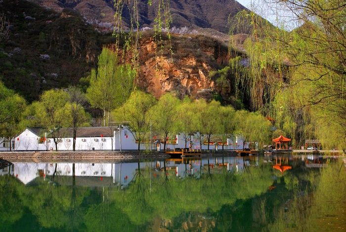
Yanqi Lake
The lake takes its name from the wild geese traditionally associated with its spring and autumn waters. In the late twentieth century it became a scenic destination; in the twenty-first, its shores were reshaped by conference architecture and global events.
 PLATE B / VALLEYS AND VILLAGES
Hundred-Mile
Landscape Gallery
Across the Baihe and Heihe valleys, fossilized trees and volcanic rock sit beside historic temples, rural settlements and memories of resistance during the 1930s. The roads now connect these stories as one cultural landscape.
History is written
in layers.
From deep geological time to village rituals and modern diplomacy, the important dates reveal how different kinds of heritage came together in northern Beijing.
years ago
The ancient forests become stone
In the region around today's Xiadelongwan Village and Baihe Valley, trees became buried and mineralized, leaving petrified wood that records an ancient environment. The same broad geological era shaped the volcanic rocks later cut by Heihe waters.
period
Village faith takes architectural form
Local worship sites emerged within mountain communities. Huapen Village's Guandi Temple is traditionally dated to the late Ming or early Qing period, while Chaoyang Temple is recorded as beginning under the Qing Kangxi emperor.
Guandi Temple is rebuilt
The temple in Huapen Village was reconstructed in the twentieth year of the Jiaqing reign. Its courtyards, stage, carved details and painted surfaces connect worship with the public cultural life of a village.
Huapen enters the history of wartime resistance
The Huapen battle took place in the Pingbei region during the war against Japanese aggression. Local revolutionary heritage adds an important twentieth-century layer to a village also known for its older temple.
Yanqi Lake opens a public chapter
Beijing approved the lake's tourism development in 1985, and the scenic area opened in 1987. Its earlier landscape identity became intertwined with leisure, accessibility and a growing public image.
Recognition of lake and geological heritage
Yanqi Lake received national 4A scenic-area recognition, while the Yanqing Petrified Wood National Geopark opened to the public in September. Both developments placed distinctive local landscapes in a wider tourism and education setting.
An entire town becomes a scenic area
On September 17, the Hundred-Mile Landscape Gallery was designated a national 4A attraction. Its “town and scenic area as one” model treats a broad inhabited landscape, rather than one enclosed site, as the destination.
Yanqi Lake enters international diplomacy
Leaders of the 21 APEC economies met by the lake in November. The meeting gave Yanqi Lake a place in a global political record, as well as a newly recognizable architectural skyline.
A continuing role on the world stage
High-level activities associated with the Belt and Road Forum returned attention to Yanqi Lake, reinforcing the symbolic role of its shores and conference spaces in contemporary Beijing.
A geography
of memory.
Explore four regional anchors. Choose a location to read how its surroundings shaped public life, cultural identity or heritage.
The lake that
changed roles.
Yanqi Lake's story begins with a name and grows into a history of public space, architecture and diplomacy.
The Chinese characters 雁栖 evoke geese coming to rest. According to the local government account, flocks have traditionally stopped by the water in spring and autumn, linking the name to seasonal migration. Long before conference buildings altered the skyline, this association connected the lake to the ecological rhythms of the Yan Mountains.
Its modern transformation began with a decision to develop the area for tourism in 1985. When the scenic area opened in 1987, the lake became accessible to a widening public, adding boating, leisure and sightseeing to its local identity. The water remained central, but people's relationship with it changed.
A further transformation came in the 2010s. The lake and surrounding architecture became recognizable images of Beijing's international engagement. What began as a remembered place of birds and water also became a stage for diplomatic meetings.

A name that remembers birds
The geese in “Yanqi” carry a local environmental story in the very name of the lake. Toponymy becomes an accessible form of cultural memory.
The scenic era
The late-1980s opening widened the lake's audience. Tourism infrastructure changed how visitors could approach, experience and photograph the shoreline.
2014 and after
The APEC leaders' meeting and later international gatherings gave the lake a diplomatic identity extending far beyond Huairou.

When architecture meets water,
a new public memory emerges.
The island as
a world stage.
Yanqi Island demonstrates how a contemporary site can acquire historical importance through what happens there.
The international conference complex at Yanqi Lake became the setting for the 22nd APEC Economic Leaders' Meeting in November 2014. Representatives of 21 member economies gathered by the lake and issued the Beijing declaration. The event established a clear historical association between this particular landscape and a significant moment in regional diplomacy.
Its buildings introduced a different kind of cultural landmark. Traditional Chinese architectural references, ceremonial spaces, landscaped grounds and the lake itself became part of a unified visual identity. The site illustrates a form of heritage still being created: political events and public images give new significance to contemporary architecture.
In May 2017, events associated with the Belt and Road Forum further strengthened the lake area's place in Beijing's international story. Yanqi Island is therefore distinct from ancient temples or geological relics: its historical value lies in the recent events, ideas and representations attached to it.
A valley full
of older stories.
Here, the history is not concentrated in one building. It stretches across mountains, riverbanks and working villages.
The Hundred-Mile Landscape Gallery lies around Qianjiadian Town in northeastern Yanqing. Its name comes from a riverside circuit traditionally measured at 112 Chinese li. Rather than a single closed attraction, the region extends across the Baihe River valley and Heihe gorge, linking many separate natural and cultural places.
These river corridors helped determine where roads and communities could develop. The same terrain also exposed exceptional geological formations: petrified trees, folded strata, lava rocks, gorges and waterfalls. Among them stand temples and village buildings that reflect community life during successive historical periods.
In 2010, the wider area became a national 4A scenic destination under an unusual town-wide model. That recognition made the connections between geology, local settlement and cultural heritage part of the identity of the entire region.
The earth
remembers first.
Before the villages and temples, the valleys already held a geological story. Three landscapes reveal how rock and water shaped the region's identity.
08–A / BAIHE VALLEYThe Petrified Wood Forest
Near Xiadelongwan Village, the remains of ancient trees have been preserved as stone. Mineral-rich conditions gradually replaced organic material while retaining traces of trunks and growth rings. These fossils turn a riverside mountain landscape into a record of vegetation and environmental conditions from roughly 140 million years ago.
Local authorities describe a substantial group of petrified trunks preserved where they originally grew, were buried and became exposed. Their significance lies not only in their appearance but in what they reveal about past climate and geological processes. Since the geopark's public opening in 2002, this deep-time story has become part of Yanqing's cultural and educational identity.
 08–B / HEIHE GORGE
Wulong Gorge
Wulong Gorge is a narrow, roughly two-kilometre river-cut landscape in an area of Mesozoic volcanic rocks. Cliffs, rock formations and pools reveal the long interaction between geological structure and moving water.
The gorge is best understood as a visible process rather than a static monument: rivers follow lines of weakness, erode material and gradually deepen a valley. The dramatic modern scenery therefore reflects forces much older than the paths and roads now used to approach it. As part of the Landscape Gallery, Wulong Gorge connects geological explanation with the everyday human experience of moving through mountain terrain.
 08–C / DISHUIHU WATERFALL
Dishuihu Waterfall
Dishuihu is associated with springs feeding a waterfall near the convergence of the two river systems. The falling water, rock face and sheltered formations give the site a distinctive appearance, while its name evokes the image of water spilling from a vessel. Together with Wulong Gorge and Baihe Valley, it illustrates why waterways have remained central to the region's landscape identity.
The lives
behind the view.
Temples, stages, courtyards and village names reveal a human history that geological landmarks cannot tell on their own.
Qianjiadian
and Chaoyang Temple
Qianjiadian is the settlement centre around which the gallery's dispersed attractions are organized. Nearby Chaoyang Temple—formerly Taishen Temple—is recorded by Beijing tourism authorities as originating during the Qing Kangxi reign. Its series of courtyards includes Buddhist and Daoist figures as well as halls connected to medicine, protection and local beliefs.
A stage near the temple entrance recalls the role of performance in communal religious life. Rather than belonging to only one neatly defined tradition, the temple complex reflects a local religious culture in which different forms of devotion could coexist. Historical temple-fair customs connected the sacred buildings with the wider community.
Huapen Village
and Guandi Temple
Huapen Village's Guandi Temple is associated with late-Ming or early-Qing origins and a documented reconstruction in 1815. Its two courtyards, halls, stage and decorative details show how a village temple could serve both as a devotional setting and as a place of collective gathering.
Local tradition connects the village's name to a stone basin discovered at the temple site. According to the story, water poured into the basin could reveal lotus flowers and swimming goldfish. Whether understood as folklore or an explanation of a place name, the story shows how a physical object can become part of a community's remembered identity.
Huapen in 1938
memory of resistance
Huapen also belongs to a much more recent historical chapter. Local government accounts identify the 1938 Huapen battle as part of the resistance struggle in the Pingbei area north of Beijing. The mountains and villages that earlier sustained everyday life became connected to wartime organization and conflict.
Today, the village's revolutionary-history exhibits sit within the wider scenic region. This layer of history changes the way Huapen can be understood: it is not only a picturesque settlement or an old temple site, but a place with political and wartime memories that continue to be interpreted locally.


The past is
still present.
The history of a landscape is not one continuous story. It is an accumulation of different lives and meanings.
Yanqi Lake shows how a familiar waterside place can gain new public and international significance. The Hundred-Mile Landscape Gallery shows how much older geological traces, religious traditions, village folklore and wartime memory can occupy the same valleys.
One landscape is associated with world leaders gathering beside a lake; another with petrified forests, temple stages and the history of rural communities. Together, they remind us that a place is never fully explained by its view.
To see the scenery is to notice the land.
To understand it is to remember the people and time within it.